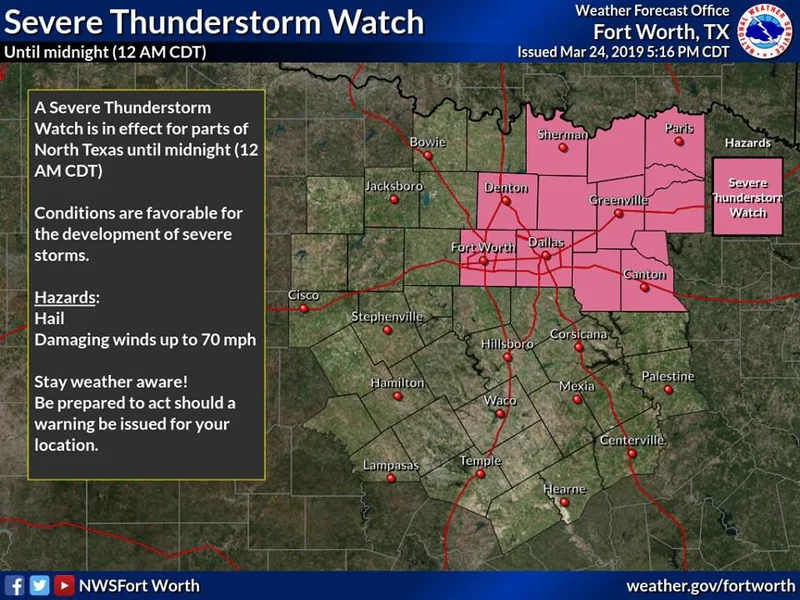
KAUFMAN COUNTY, Texas — The National Weather Service in Fort Worth, Texas, has issued a Severe Thunderstorm Watch for portions of North Texas, including Kaufman County, until midnight.
KAUFMAN COUNTY, Texas — The National Weather Service in Fort Worth, Texas, has issued a Severe Thunderstorm Watch for portions of North Texas, including Kaufman County, until midnight.
A Severe Thunderstorm Warning was issued at 7:02 p.m. and will remain in effect until 8 p.m., see details below.
The thunderstorms developed ahead of an advancing cold front and have a history of producing tennis-ball size hail, according to storm spotters in North Texas.
"Some of the storms may be severe with large hail and damaging winds the primary hazards," stated the NWS. "Although there may initially be discrete supercells near the boundary, veered surface flow and elevated cloud bases will limit the tornado potential."
"The thunderstorms will likely transition into a linear complex after midnight, primarily impacting areas that are both east of I-35 and south of I-20," stated the NWS. "Although the severe potential will diminish during the early morning hours, the line may continue to pose a damaging wind threat."
The National Weather Service in Fort Worth has issued a

* Severe Thunderstorm Warning for...
  Rockwall County in north central Texas...
  Southwestern Hunt County in north central Texas...
  Northern Kaufman County in north central Texas...
  Southern Collin County in north central Texas...
  Northeastern Dallas County in north central Texas...

* Until 800 PM CDT.

* At 701 PM CDT, a severe thunderstorm was located over Wylie, moving
  southeast at 20 mph.

  HAZARD...Tennis ball size hail and 65 mph wind gusts.

  SOURCE...Radar indicated.

  IMPACT...People and animals outdoors will be injured. Expect hail
           damage to roofs, siding, windows, and vehicles. Expect
           wind damage to roofs, siding, and trees.

* This severe thunderstorm will be near,
  Wylie and Sachse around 705 PM CDT.
  Rowlett around 715 PM CDT.
  Rockwall around 725 PM CDT.
  Fate around 730 PM CDT.
  Heath and Mobile City around 735 PM CDT.
  Royse City around 740 PM CDT.
  Terrell around 800 PM CDT.

Other locations impacted by this severe thunderstorm include
Josephine, Lavon, McLendon-Chisholm, St. Paul, Lawrence and Nevada.